With (soon to be) Hurricane Isaac's announcement a few weeks back, there has been much hype surrounding the projected path and strength of this storm upon arrival to land. A problem that occurs all to often is when people take these situations lightly and end up in trouble. Some topics I hope to cover in this discussion is not only the impacts of the hurricane (both spatially and temporally) but also some of the socioeconomic impacts as well.
So lets get started..
Hurricane Isaac started out in the mid-Atlantic as a tropical wave pattern over warm ocean waters. The warmer waters helped feed it a steady supply of moisture as it traveled across the Atlantic. With the warm waters in place, a strong shear environment ("It is the rate of change over a short duration. In wind shear, it can refer to the frequent change in
wind speedwithin a short distance. It can occur vertically or horizontally." -weather.com) is almost non-existent. A shearing environment essentially stunts the growth of the cloud tops, which completely disables it from growing.
So with the favorable environment in place in the Atlantic to initiate storm development, the Gulf of Mexico essentially puts a race car engine in tropical storm. Hurricanes need three major environments when determining if growth and strengthening are possibilities.
The first major environment is sea surface temperatures(SST). If temperatures are 27C or higher, growth can be assumed. if you take a look at the current model showing SST's for the Gulf of Mexico, you'll notice that temperatures are roughly in the 30C range. Which is excellent for hurricane growth! Another major factor involved with hurricane growth is the residence time or time that is spent over the ocean waters. Isaac is traveling through a thicker portion of the Gulf as it makes its way towards the Louisiana/Mississippi coast. Long route equals more residence time equals stronger hurricane. Finally, the last major topic to discuss is the shear environment (stated previously) and the location of the shear environment (helpful for people up north, still in the path of the fragments of the hurricane). Lucky for all of us up north, a rather strong high pressure center is located over the central plains region creating a nasty ridge which is pushing the jet stream well into the Dakotas and Canadian regions. The reason why this is important for us, is that this kind of environment is conducive for a nice extra-tropical conversion; meaning that the hurricane will be able to mix with more unstable airmasses and it will take on characteristics of an MCS or North American Synoptic front.
[caption id="attachment_46" align="alignright" width="259"]

SST for the Gulf of Mexico[/caption]
Impacts of Hurricane Isaac
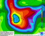
Major impacts with all hurricanes are storm surges and flooding. While it is still a little early to tell what the precise surge level will be on impact (factored by RFQ and max wind speed), it's pretty safe to say that flooding will be a problem. Once the hurricane makes land fall, friction, interactions with different airmasses and loss of energy from the warm ocean waters will begin to significantly weaken and slow the movement speed of the hurricane. The problem with a slower moving hurricane is that it will be stationary over a location for a long duration of time giving it the chance to dump tremendous amounts of water in the area. According to GFS and WRF models, Isaac will remain over the Louisiana/Mississippi coast for roughly two days. Over this time period, areas such as New Orleans, Biloxi and Mobile could see anywhere from 7-20 inches of rain from Isaac. While high rainfall amounts may not cause a high deathtoll, the damages and disruption to daily life could be very costly. People not directly affected by the hurricane's surge and heavy rain on the coast could be affected by its extra tropical progression inland (
Extra-tropical link ). As Isaac makes its approach inland Thursday evening and through the weekend, it could be very wet and stormy for Tennessee, Kentucky, Illinois, Indiana and so on. It's not uncommon for the most destructive part of the hurricane to occurs during its extra-tropical transition when phasing out over the central portions of the United States. Hurricanes in the past have caused upwards to 500year flood damage in multiple regions and gusty winds that have flattened many trees and telephone poles. So it would be a good idea to listen to all weather announcements dealing with the remnants of hurricane Isaac and to take them very seriously.
[caption id="attachment_49" align="alignright" width="150"]

Rainfall in inches[/caption]
mitigating the effects of the storm..
In order to prepare and survive the storm with as little cost, make sure to tune into your local weather stations and the National Weather Service for all warnings and watches issued. If you are living in the Louisiana/Mississippi region, you may want to consider options of leaving or evacuating to areas above sea level and boarding up homes. Remember, levies are built to withstand a 50 year flood, often times storm surges can over top these barriers. Areas outside of the direct impact of the hurricane will want to listen for heavy rain reports and to be prepared for serious flooding and all associated hazards caused by floods (flooded roads, towns, mudslides, disease in the water, ect...). If caught in the furry of the storm, proper medical supplies and food would be a great start to have near by and a sound knowledge of all escape plans.
 SST for the Gulf of Mexico[/caption]
 Rainfall in inches[/caption]
No comments:
Post a Comment